In the context of the interaction between the ongoing fires of Pedrogão Grande (Louriceira area) and a westerly sea breeze front, it was formed an isolated pyroCumulonimbus (Cumulonimbus calvus flammagenitus, International Cloud Atlas, WMO, 2017). It was photographed from Coimbra, about 30 km far from the cloud, by 16:48 UTC of the 20th June 2017 (Fig 1).
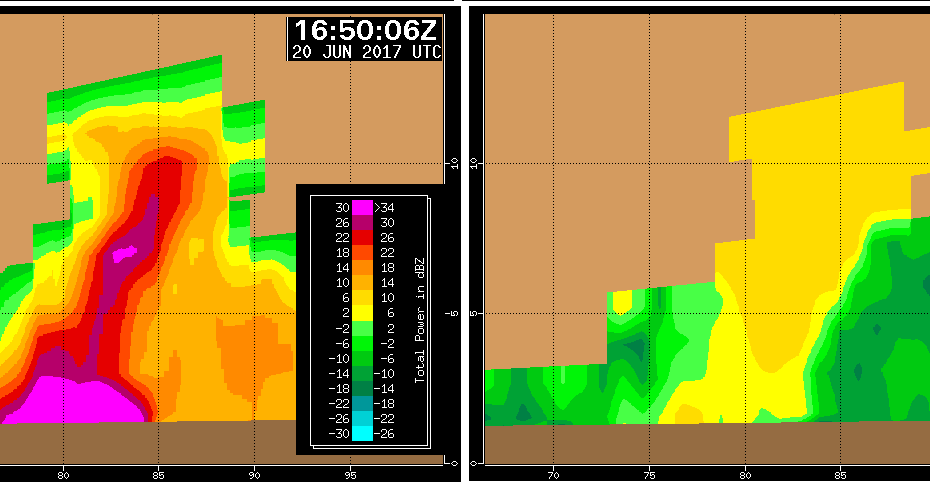
At the same time, the Arouca radar was observing the system. This Dual Polarization weather radar is able to discriminate between water cloud masses (either pure meteorological clouds or clouds derived from fires) and smoke cloud volumes of the atmosphere. The parameter used to do this is RHO_HV (correlation coefficient): values above 0.7-0.8 are typical from volumes where condensation/glaciation occurred whereas lower values are attributed to essentially smoke clouds, with no significant condensation. By 16:50 UTC, North-South vertical sections of the cloud system were obtained from radar observations. Fig 2 (left) shows a vertical section of reflectivity (information on the size and particles size and number, irrespective of their origin and microphysics) and Fig 2 (right) shows the same section of the correlation coefficient. The sections are presented as seen by an observer located to the West of them and distance markers are represented every 5 km (horizontal and vertical axes). It is outstanding to verify that the upper part of the cloud system (above 5-6 km, yellowish colors, Fig 2 (right)) is composed of condensate and glaciated parts, whereas the lower parts are dominated by smoke particles from the fire (greenish colors, Fig 2 (right)). While the lower parts are pure smoke, the upper parts resulted from a moist airmass that was fed by the sea breeze front, enabling water vapor to nucleate around multiple condensation nuclei formed by the smoke particles, as the smoke was ascending on the fire convective column. The comparison between Fig 1 and Fig 2 (right ) is very illustrative.
Vertical section of radar reflectivity (dBZ), left and Correlation coefficient (adimensional), right. Sections are North-South oriented, as seen from the West. Distance marks every 5 km (horizontal, vertical axes). 16:50 UTC, 20June2017
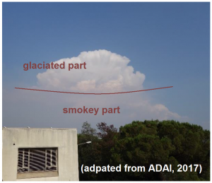
PyroCumulonimbus picture, 16:48 UTC, 20Jun2017, taken from Coimbra, 30 km far. The Cloud system is sitting over the Pedrogão Grande complex fire (Louriceira area)